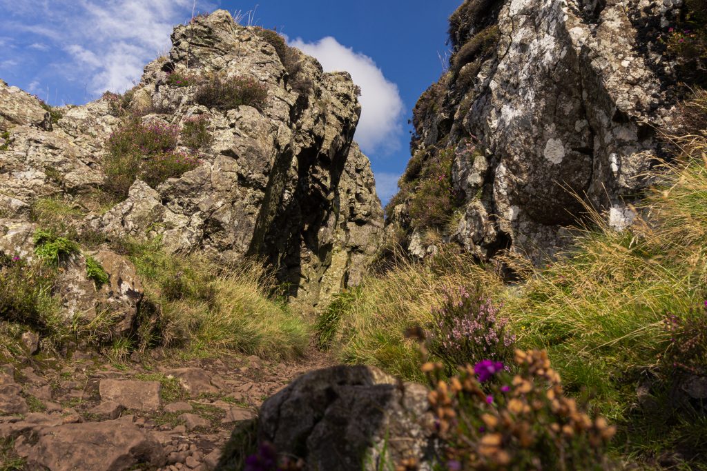
Local folklore says that The Whangie, a huge slab of basalt that has become detached from Auchineden Hill, is the work of the Devil. After hosting a gathering of witches and warlocks in the Kilpatrick Hills, he is said to have been flying to another such meeting. As he crossed Auchineden Hill, he flicked his tail, wrenching apart the hillside below.
In truth, this striking geological feature on the northern edge of the Kilpatrick Hills was caused by a geological phenomenon called glacial plucking. During the last ice age, Scotland was covered in huge glaciers that carved out the lochs and the Highlands. Here, the extreme cold froze a glacier to the hillside. As the glacier began to move, it took the rock with it, causing a long fracture to appear.
Auchinenen Hill
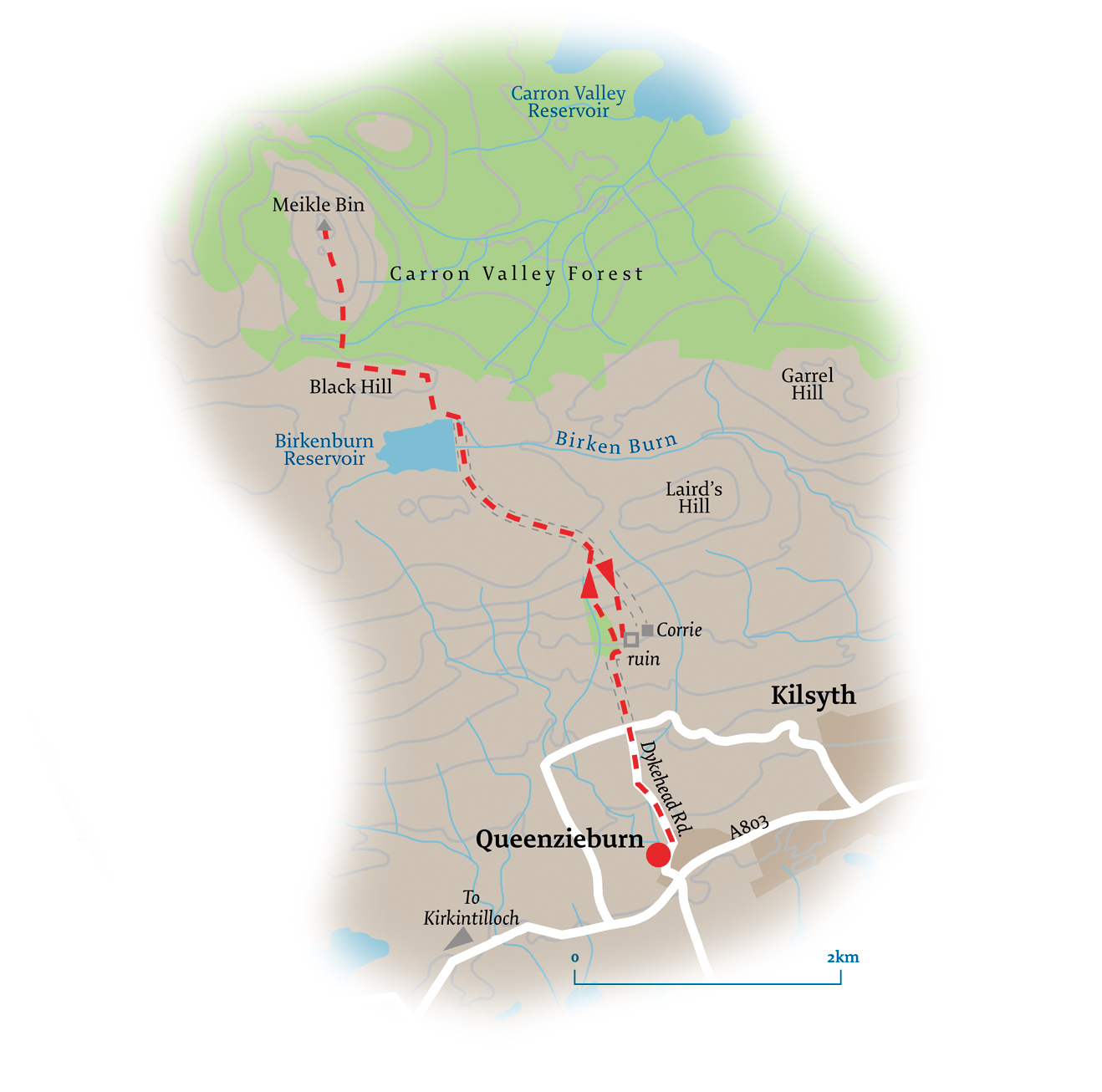
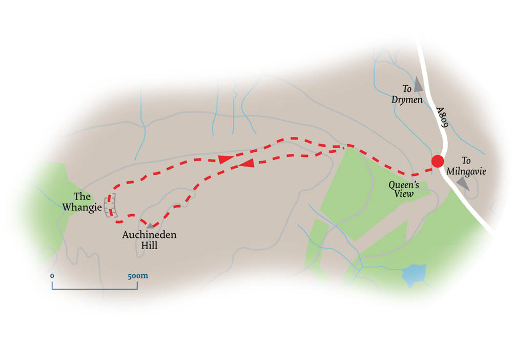
The route begins at the Queen’s View car park, just off the A809. It is so named because this spot gave Queen Victoria her first view of Loch Lomond when she visited the area in 1879. A path from the car park leads to a stone stile over a drystane dyke, beyond which a series of duckboards cross a small boggy area.
Follow a wide grassy track, passing through a gate in a deer fence and rising to a rocky outcrop. This vantage point gives great views of Ben Lomond and the Arrochar Alps, as well as Loch Lomond.
A few metres further on, by a drystane dyke, leave the path to take a track up the hill. Climb quite steeply at first before levelling out. Follow the path westwards across the wide, flat ridge of Auchineden Hill. There are several tracks here, but all ultimately converge at the trig point at the western end of the hill.
The Whangie
Continue westwards from the summit to drop down a slope. Turn left at the bottom to swing around the foot of the hill and arrive at a fork. Going right takes you into the mysterious hidden pathway known as The Whangie. Whangie is Scots for ‘slice’ – for example, ‘a whang o’cheese’. And The Whangie does indeed look as if somebody has sliced into the mountain. This leaves a chasm around 100m long, 1m wide and 9m deep. A minor scramble is required to enter, but it is an easy, if claustrophobic, passage. Alternatively, going left at the fork takes you through various jagged stones and rocky outcrops. These pinnacles were rendered from the rock by the movement of the glacier. Both paths converge again at the northern end beyond a prominent pinnacle known as The Gendarme.
Continue across the lower slopes of Auchineden Hill, which can be extremely boggy. Rise to head east below the hill’s northern escarpment, eventually joining the outward route. Follow it back to the car park.
Pocket Mountains – Stockists
FB – Velvet Moon 1203 Argyll St, Finnieston
Bluebell Gray 162 Hyndland Rd
FB – Hyndland Bookshop 143 Hyndland Rd
Waterstones 351 – 355 Byres Rd
Return to Culture and Arts